
Municipality of Cateel: Gateway to Aliwagwag Falls, 16 Barangays & Heritage Guide
Cateel is the historic coastal jewel of Davao Oriental, recognized as the oldest town and the first municipality established in Mindanao on October 29, 1903. Known officially as the Water Wonder of Davao Oriental, Cateel is celebrated worldwide for the majestic 84-tiered Aliwagwag Falls, pristine Pacific coastline, indigenous Mandaya traditions, fertile agricultural river valleys, and community resilience.
Where Pacific Breakers Meet Verdant Mountain Ranges
The Municipality of Cateel is nestled along the eastern seaboard of Davao Oriental in the southeastern region of Mindanao (Region XI). Covering a total territory of 545.56 square kilometers (210.64 square miles), Cateel accounts for approximately 9.57 percent of the entire province. The municipality is bounded on the east by the vast Pacific Ocean, on the west by the mountain ranges of Compostela (Davao de Oro), on the north by the municipality of Boston, and on the south by the municipality of Baganga.
Cateel occupies a strategic geographical crossroads connecting the Davao coastal highway to the central Mindanao mountain corridor. Its terrain transitions dynamically from sunlit sandy coastal plains and mangrove estuaries to rolling upland agricultural basins, before ascending steeply into lush tropical rainforest ridges reaching elevations above 2,400 meters. The town experiences a tropical rainforest climate (Af) marked by year-round moisture and gentle sea breezes, with rainfall peaking during the northeast monsoon (amihan) between December and February.
Historically celebrated as the oldest town in eastern Mindanao and the first municipality chartered on the island, Cateel stands today as a 1st class municipality with an official census population of 45,623 residents across 10,902 households. Its economy thrives on coconut production, copra, premium abaca fiber, rice paddies, cacao, and a rapidly expanding eco-tourism sector centered around its world-renowned waterfalls.
Water Wonder of Davao Oriental
Blessed with high mountain precipitation and untouched rainforest watersheds, Cateel harbors dozens of cascading river networks, natural spring basins, and the world-famous Aliwagwag Falls.
First Municipality in Mindanao
Organized into a civil municipality on October 29, 1903 through Organic Act No. 21 under the Legislative Council of the Moro Province, Cateel carries more than a century of documented civic history.
Remarkable Resilience
After bearing the direct brunt of Super Typhoon Pablo (Bopha) in December 2012, Cateel rebuilt its civic center, restored its eco-tourism sites, and reforested damaged canopies with admirable unity.
Aliwagwag Falls Protected Landscape: The Stairway of the Gods
Revered as one of the most stunning multi-tiered waterfalls on earth, Aliwagwag Falls cascades down 84 distinct steps spanning over 340 meters of vertical drop.
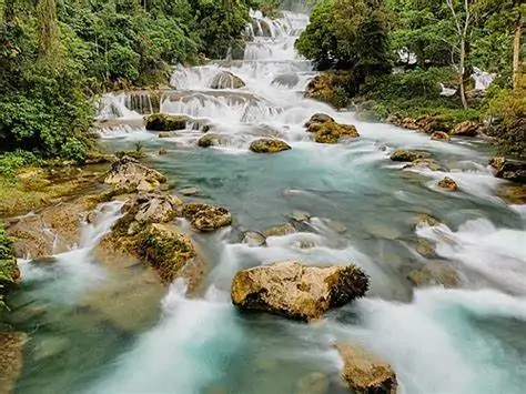
Located along the scenic Cateel to Compostela mountain highway in Barangay Aliwagwag, Aliwagwag Falls is widely acclaimed as the country’s highest waterfall system in total vertical elevation. The cataract features 84 natural stone tiers and cascades that tumble down 340 meters (1,110 feet) with a breadth of 20 meters, cutting through a dense corridor of pristine tropical rainforest.
In ancient Mandaya folklore, Aliwagwag Falls is revered as the Stairway of the Mandaya Gods (Badla and Mansilatan). Oral traditions describe the gushing white waters as the flowing silken hair of the Mandaya Ompò (revered ancestral elder woman), blessing the Cateel river valleys with abundance and continuous life.
Today, the Aliwagwag Falls Eco-Park offers eco-conscious adventures including a 68-meter-high canopy zipline spanning 320 meters across the waterfall canyon, a 45-meter monkey bridge suspension crossing, natural boulder swimming lagoons, and guided forest nature trails.
Aliwagwag Falls Eco-Park
Enjoy exhilarating canopy zipline flights directly above the roaring waterfall mist, traverse the swaying monkey bridge, and cool off in crystalline natural pools beneath ancient forest trees.
Mahan-ob Falls & Forest Springs
A serene multi-stream forested waterfall secluded within the upland river systems of Cateel, offering tranquil natural swimming lagoons, lush moss-covered rocks, and cool highland fresh water.
Mantunao Cave & Matunao Eco-Park
A remarkable limestone cave system featuring stalactite and stalagmite formations, subterranean chambers, and the scenic Tres Marias rock formations set within the Matunao Eco-Park.
Eco-Tourism Reminder: Aliwagwag Falls is a nationally protected landscape under Presidential Proclamation No. 139. Visitors are required to follow Leave No Trace principles, maintain cleanliness, respect sacred cultural sites, and coordinate with accredited municipal eco-guides.
The 16 Politically Subdivided Barangays of Cateel
Cateel is politically divided into 16 distinct barangays, encompassing bustling coastal communities, fertile agricultural river valleys, and highland forestry settlements.
Coastal & Urban Barangays
7 BarangaysBarangays situated along the Pacific shoreline and the mouth of the Cateel River, hosting government institutions, commercial commerce, coastal fishing ports, and beachfront settlements.
Agricultural & Highland Barangays
9 BarangaysBarangays nestled along the Cateel River valley and the western mountain slopes, driving coconut, copra, abaca, and rice farming, while protecting headwater catchments.
| Barangay Name | Legal Basis of Creation | Date Approved | Geographic Character | Key Landmarks |
|---|---|---|---|---|
| Poblacion | Republic Act No. 3590 | June 22, 1963 | Commercial & Civic Center | Municipal Hall, Police Station, Central Market |
| Aliwagwag | Resolution No. 169-A | August 28, 1968 | Mountain Rainforest Corridor | Aliwagwag Falls Protected Landscape, Eco-Park |
| Baybay | Resolution No. 79 | May 15, 1968 | Coastal Seaboard | Fishing Port, Mangrove Estuary, Coastline |
| Santa Filomena | Republic Act No. 3590 | June 22, 1963 | Pacific Coastline | Santa Filomena Beach, Coastal Coconut Groves |
| San Rafael | Republic Act No. 3590 | June 22, 1963 | Riverfront Plain (Historic Lapad) | Site of 1610 Spanish Landing, Farmlands |
| Taytayan | Republic Act No. 3590 | June 22, 1963 | Coastal & Estuarine | Taytayan Coast, Coconut Farms, Saltwater Channels |
| San Alfonso | Republic Act No. 3590 | June 22, 1963 | Highway Coastal Plain | Surigao-Davao Coastal Highway, Fish Landing |
| San Antonio | Republic Act No. 3590 | June 22, 1963 | Lowland Coastal Strip | Agricultural Lands, Coconut Plantations |
| Abihod (Abejod) | Resolution No. 30 | May 15, 1968 | Upland Agricultural Basin | Rice Paddies, Abaca Farms, Mountain Streams |
| Alegria | Republic Act No. 3590 | June 22, 1963 | Inland River Valley | Cateel River Basin, Corn and Rice Terraces |
| Aragon | Republic Act No. 3590 | June 22, 1963 | River Valley & Foothills | River Watershed, Local Agroforestry Groves |
| Maglahus | Republic Act No. 3590 | June 22, 1963 | River Crossing Corridor | Maglahus Hanging Bridge, River Recreation |
| Mainit | Republic Act No. 3590 | June 22, 1963 | Forested Foothills | Thermal Mineral Springs, Mahan-ob Approach |
| Malibago | Resolution No. 322 | August 16, 1969 | Upland Valley Plain | Copra Drying Centers, Mixed Crop Farmlands |
| San Miguel | Resolution No. 347 | May 15, 1969 | Inland Foothills | Forestry Reserves, Abaca Plantations |
| San Vicente | Resolution No. 90 | May 22, 1968 | Western Mountain Slopes | Upland Watershed, Cordillera Hiking Corridors |
Indigenous Mandaya Roots, Spanish Arrival & Civic Founding
Cateel’s story weaves ancient Mandaya spiritual connections with nature, early Spanish settlement in eastern Mindanao, and heroic civic rebirth.
How Cateel Got Its Name
In the year 1610, Spanish explorers Sgt. Juan Camacho de la Peña and Father Miguel de Santo Tomas arrived on the northern bank of the river at a location known as Sitio Lapad, which corresponds to modern Barangay San Rafael. After offering prayers of thanksgiving for a safe voyage across the turbulent Pacific, the visitors advanced inland along a foot trail.
They soon encountered an indigenous Mandaya tribesman seated beside the path, diligently splitting a strip of wild forest vine. When the Spanish explorers inquired in their language about the name of the place, the native hunter mistakenly assumed they were asking for the name of the tough forest vine in his hands and answered Cateel. From that memorable encounter forward, the river, the fertile coastal valley, and the expanding settlement became known as Cateel.
The Indigenous Mandaya Heritage
The Mandaya, whose name translates literally to upstream dwellers or people of the uplands, have inhabited the forested mountains, river corridors, and valleys of Cateel since pre-colonial antiquity. Renowned for their intricate craftsmanship in weaving sacred dagmay cloth from abaca fiber and crafting colorful beadwork, the Mandaya honor nature through rituals like the panawagtawag and oral epics known as dawot and bayok.
Their spiritual worldview reveres supreme deities Mansilatan and Badla, attributing the creation of Aliwagwag Falls to divine wonder where the cascading waters represent the silken locks of the Mandaya Ompò (revered tribal elder), continuously nourishing the downstream communities.
1840: Lardizabal Expedition
Governor Luis Lardizabal organized expeditions along eastern Mindanao, formally incorporating Cateel as a recognized pueblo under the Province of Caraga and the Encomienda de Bislig.
1856: Transfer to Poblacion
To take advantage of coastal maritime trade, calm fishing bays, and fresh spring waters, the original town center was relocated from Sitio Lapad to the seacoast at its present Poblacion site.
1903: Organic Act No. 21
On October 29, 1903, the Philippine Commission and the Legislative Council of the Moro Province enacted Organic Act No. 21, officially establishing Cateel as the first civil municipality in Mindanao.
Kutoo Festival & Cultural Pride
Each year, the people of Cateel celebrate the Kutoo Festival, honoring ancestral Mandaya thanksgiving rituals, indigenous music, native harvest offerings, and communal unity.
Pristine White Sands, Coastal Estuaries & River Wonders
Beyond its highland waterfalls, Cateel boasts an unspoiled Pacific coastline lined with cream sand beaches, coconut fringes, and scenic river trails.
Santa Filomena Beach
A broad expanse of cream sand beach directly facing the open Pacific Ocean, famous for soothing ocean breezes, gentle sunrise vistas, and rustic coastal relaxation.
Tongkip & Baldo Beaches
Quiet, unspoiled shorelines preferred by locals for peaceful weekend getaways, offering clear coastal waters, traditional fishing bancas, and shaded coconut groves.
Maglahus Hanging Bridge & River
A scenic pedestrian suspension bridge swinging gently over the wide Cateel River, providing breathtaking panoramic views of river rapids and lush palm canopies.
Sister's Beach & Playa Leopolda
Picturesque sandy shores tucked along the coastal coves of Cateel, where calm sea breezes and crystal-clear waters invite swimming and community gatherings.
San Victor Island Excursion
Located just south along the coastal boundary, San Victor Island is a popular island-hopping destination with immaculate white sands, turquoise waters, and marine sanctuaries.
Danog & Mabuyong Waterfalls
Lesser-known upland cascades hidden within the forested valleys of Cateel, rewarding adventurous trekkers with secluded pools and untouched natural beauty.
Municipal Leadership, Civic Services & Mayoral Heritage
Under enlightened leadership and community participation, Cateel continues to advance sustainable countryside agri-industrialization and eco-tourism promotion.
Current Municipal Leadership
The municipal government is led by Municipal Mayor Erlinda C. Nuñez, working alongside Municipal Vice Mayor Camilo T. Nuñez and the dedicated members of the Sangguniang Bayan (Municipal Council). Cateel is represented in the Philippine House of Representatives under the 1st Congressional District of Davao Oriental.
Members of the Sangguniang Bayan:
- Hon. Patrocenio I. Veroy
- Hon. Anna Cheryl N. Castro
- Hon. Alderito A. Silverio
- Hon. Michael D. Rosalia
- Hon. Isidro S. Castro
- Hon. Wilbur Y. Chua
- Hon. Brillo P. Quibo
- Hon. Nemesio C. Magno III
Official Vision: Cateel to be socially stable, economically progressive, and spiritually abiding through the pursuit of agri-industrialization and tourism promotion within the context of a balanced ecology.
Official Mission: Development of the resources and potentials towards a progressive and sustained agri-industrialized, eco-tourism destination propelled by enlightened leaders and empowered citizenry committed to sustainable countryside development.
Essential Civic Directory
- Municipal Hall (Bayan ng Cateel):
Barangay Poblacion, Cateel, Davao Oriental - Tourism Office Email:
cateeltourism@yahoo.com - Cateel Municipal Police Station (PNP):
Barangay Poblacion, Emergency Hotline Active - Municipal Health Office & District Hospital:
Barangay Poblacion, Primary Emergency & Maternal Care - Electric Cooperative (DORECO):
Davao Oriental Electric Cooperative, Cateel Substation - Official Website:
cateel.gov.ph
Chronology of Municipal Chief Executives
From Municipal Presidents during the early American civil government to modern elected Municipal Mayors:
| Municipal Executive | Term of Office | Designation / Milestone |
|---|---|---|
| Remegio Magno | 1900 to 1902 | First Municipal President under American Military Government |
| Claudio Gonzales | 1903 to 1905 | Municipal President during charter enactment of Organic Act No. 21 |
| Domingo Ibañez | 1905 to 1906 | Municipal President |
| Mariano Dacuycuy | 1907 to 1912 | Appointed Municipal President under American Civil Government |
| Lorenzo Balmori | 1913 | Municipal President |
| Luciano P. Villasin | 1914 to 1915 | Municipal President |
| Jacinto Enriquez | 1916 to 1924 | Municipal President overseeing early road and school expansion |
| Gregorio Dacuycuy | 1925 to 1931; 1941 to 1944 | Municipal President; later Provincial Board Member |
| Francisco Enriquez | 1932 to 1940 | Municipal President during the Philippine Commonwealth |
| Julian Gonzales | 1944 to 1945 | Appointed by local resistance forces during World War II |
| Pedro Losentes | 1946 to 1947 | Appointed by President Manuel Roxas following liberation |
| Francisco Castro | 1948 to 1951 | First post-war elected Municipal Mayor of Cateel |
| Santiago Silverio | 1952 to 1963 | Municipal Mayor during conversion of Mainit and Alegria into barrios |
| Pedro Castro | 1964 | Municipal Mayor (passed away in office on May 6, 1964) |
| Misael Clamor | 1964 to 1967 | Municipal Mayor succeeding to office |
| Elano Cabrera | 1968 to 1971 | Municipal Mayor overseeing creation of new barangays |
| Proculo B. Abarca | 1972 to 1983 | Municipal Mayor (passed away in office on May 13, 1983) |
| Giselo V. Castillones | 1983 to 1986 | Municipal Mayor |
| Agardo D. Reyes | 1986 | Appointed Officer-in-Charge Mayor by President Corazon C. Aquino |
| Nemesio M. Magno | 1986 to 1987 | Appointed Officer-in-Charge Mayor |
| Dr. Isidro S. Castro | 1988 to 1995 | Elected Municipal Mayor |
| Camilo T. Nuñez | 1995 to 2004; 2007 to 2016 | Multi-term Municipal Mayor; presently serving as Vice Mayor |
| Erlinda C. Nuñez | Incumbent | Serving as Municipal Mayor, leading eco-tourism and recovery |
How to Travel to Cateel, Davao Oriental
Cateel is accessible by land transportation from Davao City, Tagum City, Mati City, and Surigao del Sur through paved coastal and mountain highways.
Route 1: Via Tagum & Compostela (Fastest from Davao)
From Davao City or Tagum City Overland Transport Terminal, board an air-conditioned passenger bus or UV Express passenger van bound for Cateel via Montevista and Compostela in Davao de Oro.
This scenic mountain highway traverses directly across the Compostela cordillera and passes immediately alongside the entrance of Aliwagwag Falls before reaching Barangay Poblacion. Travel time is approximately 4 to 5 hours from Tagum City (around 190 km) and 5 to 6 hours from Davao City (around 245 km).
Route 2: Via Mati City & Coastal Highway
Travelers originating from Mati City or southeastern Davao Oriental can take the Surigao to Davao Coastal Highway northward through Manay, Caraga, and Baganga to Cateel.
This picturesque coastal route hugs the dramatic cliffs of the Pacific Ocean, crossing wide river bridges and coconut groves. Distance from Mati City is roughly 160 kilometers, with a typical travel time of 3 to 3.5 hours by private vehicle or public bus. From Bislig City (Surigao del Sur) in the north, Cateel is approximately 75 kilometers away (about 1.5 hours drive).
Landmarks of Cateel: Civic Hubs & Natural Splendor
Authentic photographic views showcasing the public institutions, town center, and natural wonders of the Municipality of Cateel.


Pacific Eco-Tourism Hub
From the misty forest spray of Aliwagwag Falls to the golden morning sun rising over the Pacific ocean at Santa Filomena, Cateel welcomes explorers seeking authentic Mindanao beauty.
View Visitor FAQsEssential Visitor & Resident Inquiries for Cateel
Helpful answers covering travel logistics, best times to visit Aliwagwag Falls, municipal ZIP code, local safety, and accommodations.
Why is Cateel called the Water Wonder of Davao Oriental?
Is Cateel really the oldest municipality in Mindanao?
How many barangays comprise the Municipality of Cateel?
What is the unified ZIP code and postal designation for Cateel?
When is the best time of year to visit Aliwagwag Falls?
What cultural festival is celebrated in Cateel?
How long is the travel time from Davao City and Tagum City?
What are the primary agricultural products and livelihood of Cateel?
Custom Event Shirts, Festival Jerseys & Uniforms for Cateel
RB Advertising (phshirt.com) is the premier regional apparel and merchandise manufacturer for Davao Oriental. We supply high-performance sublimation team jerseys, festival celebration shirts for the Kutoo Festival and Araw ng Cateel, municipal and barangay official uniforms, corporate workwear, school sports kits, and tour guide apparel.
- Full-sublimation dri-fit jerseys with vibrant colors that never crack or fade
- Precision computer embroidery for LGU emblems, police patches, and school seals
- Fast, reliable inter-provincial shipping directly to Cateel via Bachelor Express or courier
Connect with RB Advertising
Reach our team directly through our canonical contact channels. Business hours: Mon to Sat, 8:30 AM to 5:00 PM (PHT). Visit our Tagum City facility at Naungayan Building, Aala Road, Barangay Mankilam, Tagum City.