
Municipality of Barobo: The Breathtaking Paradise of the Pacific, 22 Barangays & Tourism Guide
Barobo is a vibrant coastal municipality and vital transport crossroads in central Surigao del Sur. Carved from Lianga on October 24, 1960 through Executive Order No. 407, Barobo is celebrated for the powdery white shores of Cabgan Island, the crystalline depths of Bogac and Beto cold springs, expansive Pacific beaches, rich Kamayo heritage, and the newly established Barangay Guinhalinan under Republic Act No. 11986.
The Strategic Maritime Junction of Eastern Mindanao
Where central Surigao del Sur links coastal highways with the fertile interior valleys of Agusan del Sur.
The Municipality of Barobo occupies a premier geographical position along the central eastern coastline of Mindanao, facing the Pacific Ocean and Lianga Bay. Geographically situated between 8°34′00″ and 8°25′00″ north latitude and 125°59′00″ and 126°22′04″ east longitude, Barobo spans 242.50 square kilometers (24,250 hectares), representing 4.92 percent of the provincial land area of Surigao del Sur.
Barobo serves as the primary regional convergence point for land transportation. It is bounded on the north by Lianga Bay and the municipality of Lianga, on the south by the municipality of Tagbina, on the southeast by the municipality of Hinatuan, on the east by the Pacific Ocean and Hinatuan Bay, and on the west by the municipality of San Francisco, Agusan del Sur. The town is connected via the national coastal highway network to the provincial capital of Tandag City, located 103 kilometers to the north, and Bislig City to the south.
The terrain rises from sea level along pristine tidal flats, white sand bars, and mangrove estuaries to rolling hills and forested limestone peaks that reach elevations of 279 meters above sea level. The clean Barobo River flows through the heart of the municipality, emptying into the sheltered waters of Barobo Bay, where local fishing boats and island hopping bancas dock safely.
Key Municipal Coordinates
Geographic Coordinates: 8°31′45″N, 126°07′18″E (8.536135, 126.120328)
PSGC Code: 1606801000 (Region XIII, Surigao del Sur)
Postal ZIP Code: 8309 (PhilPost Barobo Post Office)
Telephone Area Code: +63 (086)
Demonym: Barobohanon
Climate Classification: Corona Type II (no pronounced dry season, peak rainfall during northeast monsoon November to February)
Pristine White Sands, Sandbars & Offshore Islets
Barobo boasts over 15,000 hectares of municipal waters and coastal reserves featuring world-class island hopping circuits.
Cabgan Island
The crown jewel of Barobo island hopping, located a 30 to 45 minute outrigger banca ride from Barobo Port. Cabgan features an extensive crescent of blindingly fine white sand, towering coconut palm groves, and translucent turquoise shallows.
On the eastern side of Cabgan Island lies West Cabgan Islet, dramatic limestone cliff formations that face the roaring open Pacific Ocean, providing exhilarating viewpoints for hikers and photographers.
Turtle Island (Isla Verde)
Named for its distinctive silhouette that mirrors a giant sea turtle resting quietly on the surface of the Pacific, Turtle Island is surrounded by vibrant coral reefs and thriving marine life.
Visitors can disembark on its white pocket beaches, trek along gentle limestone slopes to panoramic ridgelines, and enjoy 360-degree views overlooking the municipal waters of Barobo and the Pacific horizon.
Vanishing Island (Vanishing Bar)
A pristine sandbar of pure white coral sand that emerges majestically during low tide and the local ayaay tidal season near Cabyao Islet. As the tide recedes, an expansive shallow sandbar appears.
The crystal-clear water around Vanishing Island is home to abundant starfish, sea urchins, and coastal shells, creating a serene, shallow swimming paradise ideal for children and families.
Panaraga Golden Beach
Spanning the coastal borders of Sitio Panaraga in Barangay Gamut and Barangay Unidad, Panaraga Golden Beach features an uninterrupted shoreline of soft golden sand backed by coastal vegetation.
During the northeast monsoon (Amihan) from November through February, consistent Pacific swells roll into the bay, transforming Panaraga into an exciting coastal destination for surfing, skimboarding, and beachfront camping.
Radin's Hidden Camping Site
Nestled discreetly in Sitio Malindog, Barangay Gamut, this secluded coastal haven combines a tranquil white sand beach, towering coconut palms, and dramatic stone arches.
The site features a cave entrance opening toward the blue Pacific waters, along with natural rock tidal pools where visitors can safely swim, snorkel, and pitch tents under starry skies.
Dapdap Beach & Leisure Parks
Barangay Dapdap is home to popular family-friendly coastal accommodations including 3 As' Beach Resort and nearby Ragga Ragga Leisure Park, offering covered cottages, grilling stations, and seaside dining.
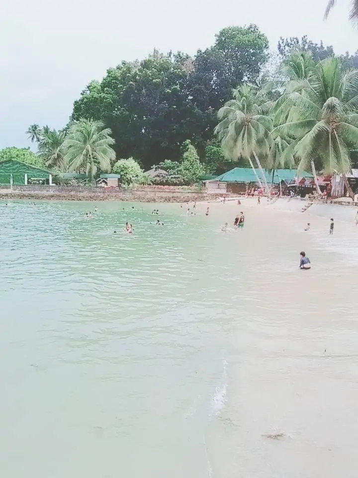
These mainland beaches provide immediate access to calm waters, scenic mangrove estuaries, and direct arrangements for island hopping boats chartered by local boat operators.
Bogac Cold Spring, Beto Lagoon & Wakat Cave
Karst geology feeds freezing freshwater pools and subterranean caverns steeped in municipal history.
Bogac Cold Spring
Located conveniently in Purok 1A of Barangay Poblacion, Bogac Cold Spring is a beloved town landmark celebrated for its ice-cold, bluish brackish spring water that bubbles constantly from subterranean aquifers.
The municipality has maintained developed swimming pools and picnic pavilions here, making it a favorite retreat for weekend family gatherings, birthday picnics, and swimming lessons for local youth.
Location: Purok 1A, Poblacion, Barobo
Water Type: Icy blue brackish spring, continuous flow
Beto Lagoon (Beto Cold Spring)
Beto Lagoon is a breathtaking natural cold spring pool surrounded by dense, verdant forest foliage and towering trees. Renowned for its mysterious depth and vivid emerald-green coloration, Beto maintains an unmeasured subterranean sinkhole.
Visitors can enjoy refreshing swims, bamboo raft rides across the lagoon, and observe varied indigenous freshwater fish species swimming peacefully through crystal clear depths.
Location: Purok 1A / Beto, Barobo
Experience: Emerald deep lagoon, bamboo rafting, diving
Wakat Cave (Pagbutuanan Cave)
Wakat Cave (historically documented as Pagbutuanan Cave in Executive Order No. 407) is an ancient limestone karst cavern in Barangay Wakat. It marks Point A of the legal municipal boundary created in 1960.
The cave interior features intricate stalactite and stalagmite formations, colony roosts of native fruit bats, and cold subterranean freshwater channels that drain out into coastal mangrove estuaries.
Location: Barangay Wakat, Barobo
Historical Significance: Official Point A in EO 407 municipal charter
Responsible Eco-Tourism Advisory: When visiting Bogac Cold Spring, Beto Lagoon, and offshore islands, please observe municipal environmental ordinances. Barobo strictly implements clean coast protocols: carry all food wrappers and trash back to the mainland, avoid using chemical soaps in natural spring pools, and respect wildlife sanctuaries.
The 22 Politically Subdivided Barangays of Barobo
Detailed demographics, PSGC codes, and community profiles, including the newly enacted Barangay Guinhalinan.
Barangay Guinhalinan: The 22nd Constituent Barangay of Barobo
On March 21, 2024, the Philippine legislature officially approved Republic Act No. 11986, entitled "An Act Creating a Barangay in the Municipality of Barobo, Province of Surigao del Sur, to be known as Barangay Guinhalinan." Carved out of Barangay Poblacion to enhance public service delivery and local governance, Guinhalinan officially elevated Barobo from its historic 21 barangay composition to 22 constituent barangays.
| Barangay Name | PSGC Code | 2020 Population | Share of Pop. | Key Characteristic |
|---|---|---|---|---|
| Amaga | 1606801001 | 3,010 | 5.66% | Inland agricultural community along transit corridor |
| Bahi | 1606801002 | 2,123 | 3.99% | Coconut farming, rice paddies, and agro-forestry |
| Cabacungan | 1606801003 | 1,659 | 3.12% | Coastal and estuarine fishery settlement |
| Cambagang | 1606801004 | 2,616 | 4.92% | Inland farming and agro-rural livelihoods |
| Causwagan | 1606801005 | 608 | 1.14% | Tranquil upland farming community |
| Dapdap | 1606801006 | 1,678 | 3.16% | Coastal beach resorts (3 As' Resort, Dapdap Beach) |
| Dughan | 1606801007 | 1,297 | 2.44% | Agricultural land producing copra and root crops |
| Gamut | 1606801008 | 3,510 | 6.60% | Panaraga Beach, Radin's Camping Site, Ragga Ragga Park |
| Guinhalinan | 1606801022 | Chartered 2024 | Evolving | Created under RA 11986 (March 21, 2024) from Poblacion |
| Javier | 1606801009 | 3,694 | 6.95% | Major agricultural community with fertile river plains |
| Kinayan | 1606801010 | 1,351 | 2.54% | Highland crop farming and coconut plantations |
| Mamis | 1606801011 | 542 | 1.02% | Quiet upland farming community |
| Poblacion | 1606801012 | 14,534 | 27.35% | Municipal Hall, Public Market, Bogac Spring, Transport Hub |
| Rizal | 1606801013 | 1,885 | 3.55% | Agricultural settlement named in honor of Dr. Jose Rizal |
| San Jose | 1606801014 | 1,154 | 2.17% | Upland agricultural barangay with rolling terrain |
| San Roque | 1606801015 | 816 | 1.54% | Rural community center and coconut farming |
| San Vicente | 1606801016 | 1,366 | 2.57% | Historic agricultural settlement listed in 1960 charter |
| Sua | 1606801017 | 939 | 1.77% | Inland agricultural lands and agro-forestry |
| Sudlon | 1606801018 | 370 | 0.70% | Peaceful interior hamlet with lush mountain views |
| Tambis | 1606801019 | 6,344 | 11.94% | Major commercial highway junction on Agusan corridor |
| Unidad | 1606801020 | 978 | 1.84% | Coastal barangay sharing Panaraga Beach waters |
| Wakat | 1606801021 | 2,672 | 5.03% | Wakat Cave (Pagbutuanan Cave), historical Point A |
Barangay Poblacion & Civic Center
14,534 ResidentsThe administrative, commercial, and financial heart of Barobo. Poblacion houses the Municipal Hall, legislative offices, rural health unit, Barobo Central Elementary School, integrated bus terminal, and public market.
Barangay Tambis Highway Corridor
6,344 ResidentsThe second most populous barangay in Barobo, Tambis represents the vital interior trading post along the junction connecting Surigao del Sur with Agusan del Sur, featuring bustling wholesale commerce and agriculture.
Barangay Gamut Eco-Coastline
3,510 ResidentsThe premier eco-tourism destination on the mainland, Gamut encompasses Sitio Panaraga Beach, Radin's Hidden Camping Site, and dramatic limestone coastal caves looking directly out at the Pacific Ocean.
Barangay Wakat Historical Frontier
2,672 ResidentsA historically foundational barangay containing Pagbutuanan Cave (Wakat Cave), the exact Point A documented by President Carlos P. Garcia in the 1960 presidential creation order for Barobo.
From Ancient Manobo Lands to an Independent Municipality
Executive Order No. 407, President Carlos P. Garcia, and the historic Barobo tree.
Centuries before modern administrative demarcations, the lands of Barobo were inhabited by indigenous Manobo tribesmen who revered the surrounding lush forests, pristine rivers, and coastal bluffs. During the 1930s, five pioneering fishing families arrived at the mouth of the river, establishing a settlement drawn by the sheltered natural harbor and bountiful fish catches in Lianga Bay.
The settlement took its name from an endemic tree species known locally as Barobo (botanical name: Diplodiscus paniculatus), which grew abundantly along the riverbanks, limestone outcrops, and coastal perimeter. As more families arrived from neighboring provinces to farm and fish, Barobo grew into a major barrio under the mother municipality of Lianga.
On October 24, 1960, President Carlos P. Garcia signed Executive Order No. 407, entitled "Creating the Municipality of Barobo in the Province of Surigao del Sur." The order segregated the barrios and sitios of Barobo, Wacat, San Vicente, Amaga, Bahi, Canbagang, Javier, Yaco, Dapdap, Kinayan, Rizal, Gamut, and Cabacungan from Lianga, establishing Barobo as an independent municipality with its seat of government at Barrio Barobo.
The official municipal boundary was demarcated starting at Point A, the mouth of Pagbutuanan Cave at Sitio Wacat, extending west to the provincial boundary of Surigao del Sur and Agusan, southward along the provincial border to Hinatuan, and eastward across the marine waters back to Wacat. In 1938, President Manuel L. Quezon had previously signed Proclamation No. 306, reserving three public parcels in Barrio Barobo for aviation landing facilities, highlighting its long-standing strategic importance.
Chronology of Barobo Governance
- Pre-Colonial Era: Indigenous Manobo ancestral domains and river settlements.
- 1930s: Fishing families settle at river mouth; community named after the Diplodiscus paniculatus (Barobo) tree.
- 1938: Proclamation No. 306 by President Manuel L. Quezon reserves airfield parcels in Barrio Barobo.
- June 1960: Republic Act No. 2786 divides the historic province of Surigao into Surigao del Norte and Surigao del Sur.
- October 24, 1960: Executive Order No. 407 by President Carlos P. Garcia formally creates the Municipality of Barobo from Lianga.
- March 21, 2024: Republic Act No. 11986 creates Barangay Guinhalinan, establishing 22 total barangays.
The Economic Crossroads of Central Surigao del Sur
Thriving agriculture, prolific marine fisheries, eco-tourism hospitality, and bustling retail commerce.
Agriculture & Agro-Forestry
Agriculture represents the cornerstone of Barobo's rural economy. Vast coconut plantations yield premium copra and raw materials for processing.
Inland plains and river valleys in Javier, Bahi, Rizal, and Amaga support extensive irrigated rice paddies, corn, high-value bananas, cacao, and vegetables supplied to regional markets.
Marine Fisheries & Aquaculture
Facing both Lianga Bay and the open Pacific Ocean, Barobo benefits from nutrient-rich marine waters. Local fishermen land yellowfin tuna, mackerel, grouper, and blue crabs.
Mangrove channels in Cabacungan and Wakat sustain thriving municipal fish corrals, crab fattening pens, and sustainable coastal mariculture that feed local eateries.
Regional Transport & Trading
As the central junction connecting the coastal corridor with Agusan del Sur, Barobo experiences heavy daily passenger and cargo traffic.
Poblacion and Tambis host commercial banking, cooperative financial institutions, wholesale grocery suppliers, hardware depots, and lively roadside food establishments.
Peer-Reviewed Coastal Research on Barobo Beaches
Scientific insights from the Journal of Marine and Island Cultures (JMIC) on environmental conservation.
In a 2022 peer-reviewed environmental study published in the Journal of Marine and Island Cultures, researchers Sherley Ann T. Inocente and Dr. Hernando P. Bacosa from the Mindanao State University (MSU-IIT) conducted an in-depth ecological survey titled "Assessment of Macroplastic Pollution on Selected Tourism Beaches of Barobo, Surigao Del Sur, Philippines."
The scientific team surveyed four primary coastal tourism destinations in Barobo: Cabgan Island, Turtle Island, Dapdap Beach, and Panaraga Beach. By establishing rigorous transect lines and quadrats, the study analyzed plastic litter density, comparing offshore island shores with mainland coastlines.
Crucially, the study's Clean Coast Index (CCI) calculations revealed that the tourist beaches of Barobo rank as "Clean" and "Moderately Clean" by international coastal standards. The authors emphasized that proactive municipal waste segregation, community clean-up initiatives, and eco-tourism guidance from the local government unit play an essential role in preserving Barobo's marine biodiversity.
Key Scientific Findings (JMIC 2022)
- Clean Coast Index: Tourist beaches achieved "Clean" and "Moderately Clean" international benchmark scores.
- Surveyed Sites: Cabgan Island, Turtle Island, Dapdap Beach, and Panaraga Golden Beach.
- Ecological Call to Action: Continued enforcement of single-use plastic restrictions for island hopping bancas.
- Academic Citation: Inocente & Bacosa (2022), J. Mar. Isl. Cult. 11(1): 14, DOI: 10.21463/jmic.2022.11.1.14.
How to Travel to Barobo, Surigao del Sur
Essential transport corridors, bus options, airports, local accommodations, and Apple Maps link.
Air & Overland Transit Routes
From Butuan City (Bancasi Airport): Take a public passenger bus (Bachelor Express bound for Bislig or Mangagoy) or a passenger passenger van via San Francisco (San Franz), Agusan del Sur. Direct travel time is approximately 2.5 to 3 hours over well-paved national highways.
From Davao City: Board an air-conditioned bus via Davao - Tagum - Trento - San Francisco (Cuevas) - Barobo route. Travel duration is approximately 4.5 to 5.5 hours, making Barobo a convenient coastal getaway from the Davao metropolitan area.
From Tandag City (Provincial Capital): Regular passenger buses and vans run south along the Surigao coastal highway (103 kilometers), with travel times averaging around 2 hours.
From Hinatuan (Enchanted River): Barobo is located only 30 to 45 minutes northwest of Hinatuan, making it effortless to combine both destinations in a single day tour.
Local Lodging, Dining & Logistics
Town Accommodations: Barobo provides hospitable tourist inns and lodges clustered in Poblacion and along the coast, including Ankerdoll Tourist Inn, Terraza Victoria Lodge, Alizer Travellers Inn, My Choi's Place, and coastal resorts like Pongpong Resort and 3 As' Beach Resort in Dapdap.
Local Dining: Enjoy fresh seafood and local delicacies in Poblacion at Tuna Republik, Meriendas ni Mama Inday, Margaux Cafe, Edong's Diner, Sam's Cafe, and Jarc.
Getting Around Town: Local motorized tricycles provide economical transport within Poblacion and to Bogac Spring. Habal-habal motorcycles service upland barangays. Motorized outrigger bancas can be chartered at Barobo Port or Haga Port for island hopping tours.
Visual Highlights of Barobo
Essential Questions & Answers About Barobo
Clear guidance on travel logistics, natural wonders, legal history, and municipal profile.
Why is Barobo called The Breathtaking Paradise of the Pacific?
How many barangays comprise the Municipality of Barobo?
When was Barobo established and from what town was it carved?
Where did the name Barobo originate?
What is the Clean Coast Index rating of Barobo's beaches?
How do travelers reach Cabgan Island and the offshore islets?
What is the unified ZIP code and postal designation for Barobo?
What local language is spoken in Barobo?
Custom Event Shirts, Festival Uniforms & Corporate Apparel for Barobo
RB Advertising (phshirt.com) is the leading Mindanao apparel and uniform manufacturer, proudly supplying government offices, cooperatives, public schools, private businesses, and eco-tourism operators across the Municipality of Barobo and Surigao del Sur.
- Full-sublimation dri-fit shirts and jerseys with vibrant colors that withstand sun and salt water
- Precision computer embroidery for LGU municipal emblems, police badges, and institutional logos
- Fast, direct freight delivery straight to Barobo terminal via Bachelor Express or regional door-to-door couriers
Connect with RB Advertising
Reach our production team directly through our canonical contact channels. Business hours: Mon to Sat, 8:30 AM to 5:00 PM (PHT). Visit our main production facility at Naungayan Building, Aala Road, Barangay Mankilam, Tagum City.